Text & Photographs: Marcella van Alphen & Claire Lessiau
Ready for take-off! Our small Cessna 206 is speeding down the runway at the Maria Reiche Neuman Airport, also known as Nazca Airport. Named after the pioneering German-born Peruvian archaeologist, mathematician, and leading researcher of the Nazca Lines, this hub serves as the gateway for travelers eager to explore one of world’s most enigmatic archaeological wonders. While the creators who etched gigantic animal figures and geometric shapes into the arid terrain of the Nazca Desert were not able to fly, the over 2,000-year-old figures can only be truly appreciated from the sky. These colossal geoglyphs have captivated explorers, researchers, and curious travelers alike. Despite being one of the world’s most famous archaeological marvels, the Nazca Lines remain cloaked in mystery, observed from the sky by only a fortunate few. Hop aboard to explore more about this fascinating site!
Pin it for later!

Desert of secrets: unraveling the mysteries of the Nazca Lines
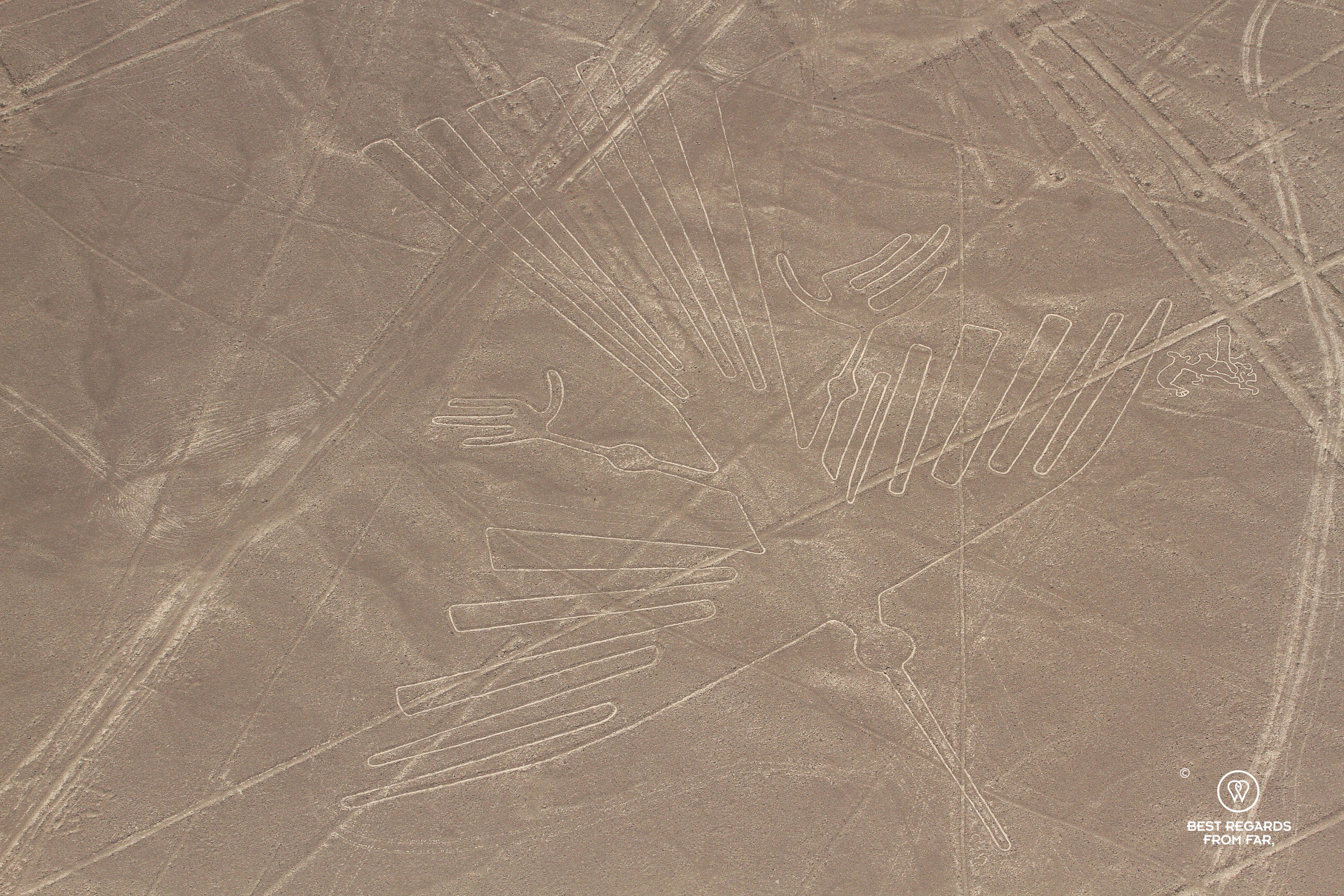
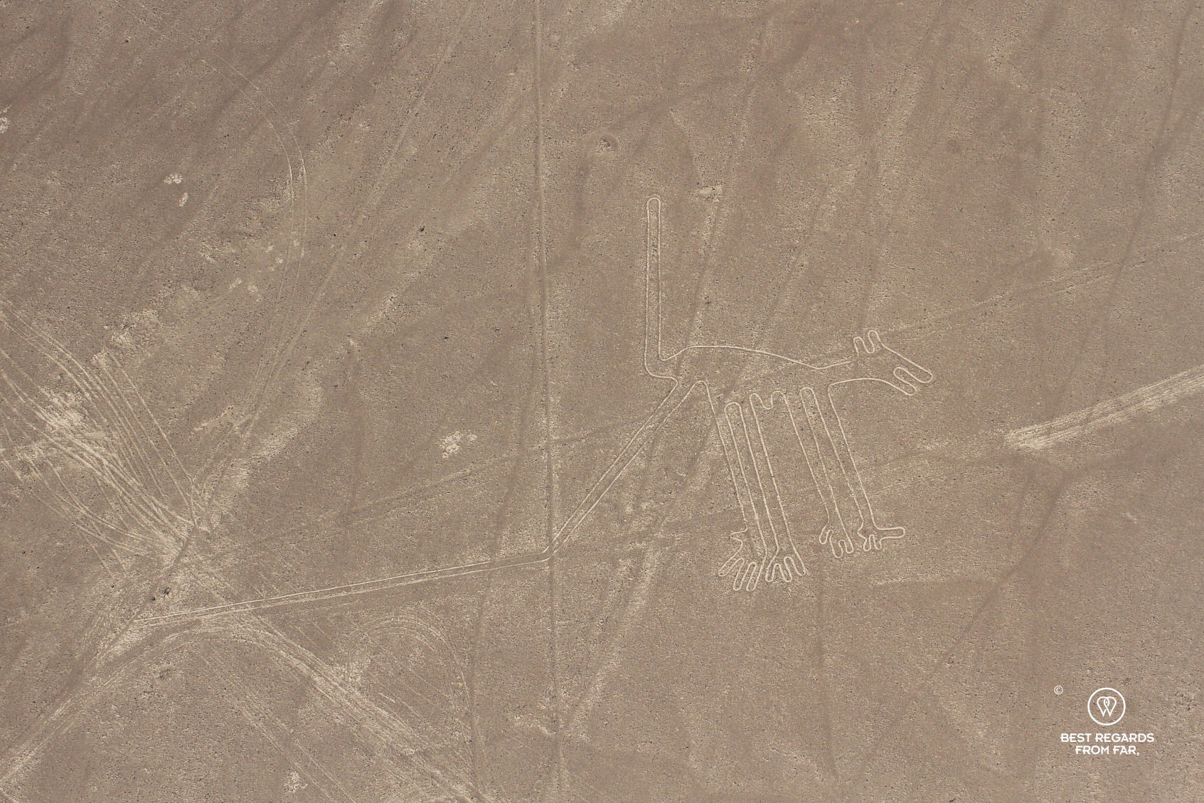
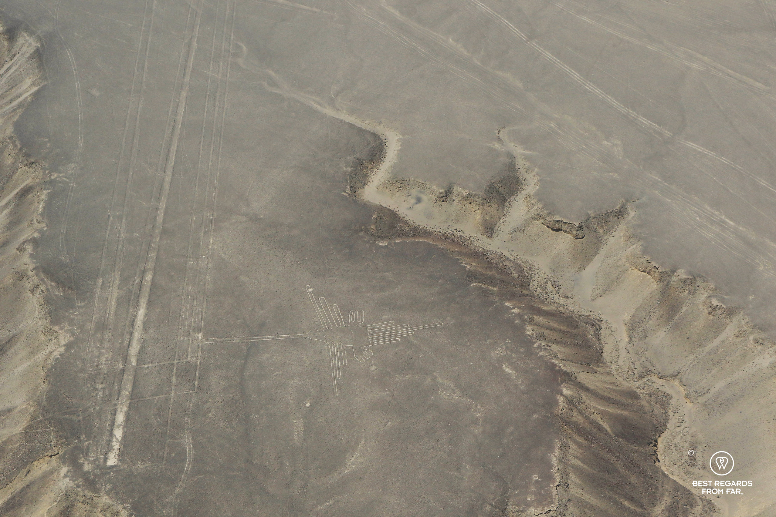
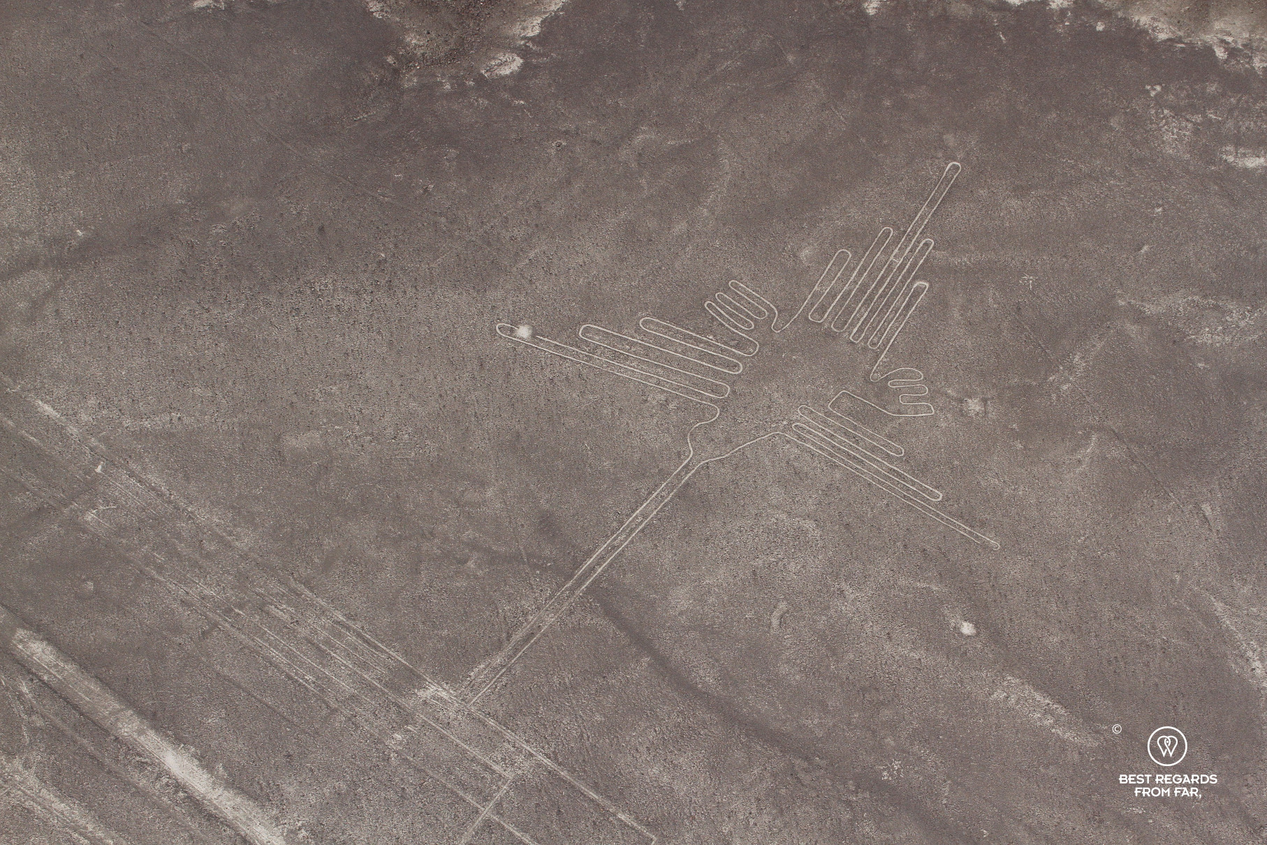
The Nazca Desert, one of the driest places on Earth, is home to the Nazca Lines which span an area of over 440 square kilometers (170 square miles) on the arid southern Peruvian coastal plain. Comprised of over 1,000 geoglyphs, the Nazca Lines date back more than 2 millennia to the era of the ancient Nazca culture. The geoglyphs are striking in their diversity of design and monumental scale—some animal figures, such as the hummingbird, monkey, and whale stretch up to 370 meters (1,200 feet).


By meticulously removing the top 30-40 centimeters (12-15 inches) of rusty-colored iron oxide-coated pebbles which cover the desert, the Nazca people have exposed the lighter yellow sand beneath, creating a stark color contrast. The low rainfall, scarce wind, and the lime-rich soil, which hardens under the morning mist have all contributed to the preservation of their designs over the thousands of years.
From lines, geometric figures to animal designs
As our small aircraft gains altitude, our guide invites us to look down beneath the left wing to spot our first geoglyph. A whale becomes apparent, followed by a monkey, a hummingbird, flower, spider, and condor just to name a few. Referred to as pictorial representations, there are approximately 700 of these figures, showcasing the artistic skills of the Nazca people.
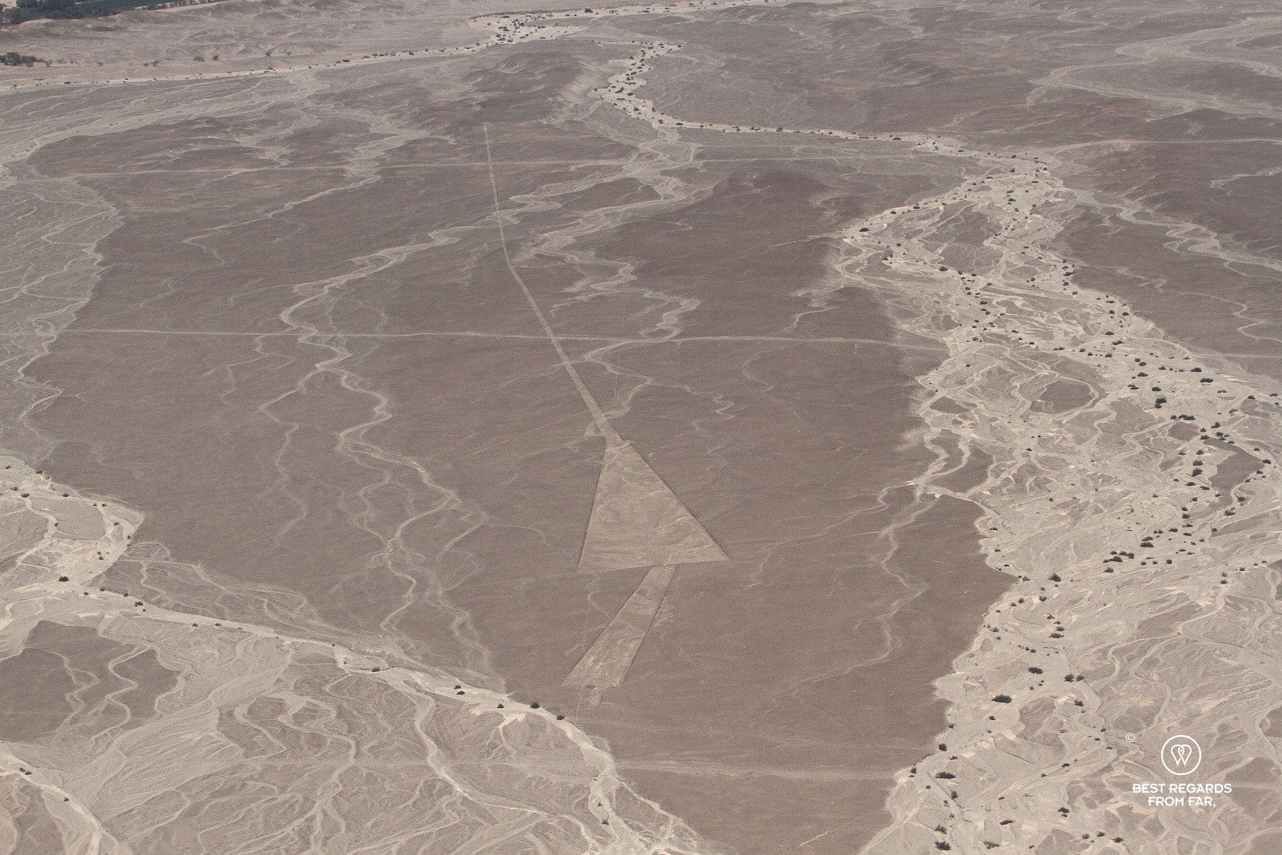
In addition to the artistic animal representations, our copilot points out the wide array of geometrical shapes such as triangles, rectangles, spirals, and zig-zags. About 300 of them cover the arid Nazca Desert and researchers conjecture that these complex patterns may have had astronomical or ceremonial significance.

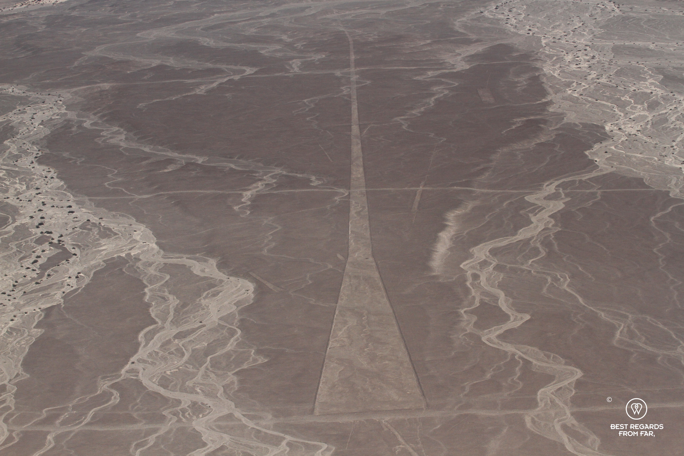

While the plane keeps circling and rolling to give each of us the opportunity to mesmerize over the lines, we start noticing the seemingly never-ending straight lines. Not as artistic as the animal representations or geometrical shapes, a baffling estimated 800 of these straight lines can be found crisscrossing the desert, some as long as 48 kilometers (30 miles). The sight of it all leaves us dazzled as we eagerly snap our photographs.
Drawing history with math, ropes & sticks
In the 1980’s, Dr. Joe Nickell, a researcher from the University of Kentucky, successfully recreated some of the Nazca Lines’ iconic animal figures using mathematical homothety. By using tools and materials that would have been available to the ancient Nazca people—such as ropes, wooden sticks, and white lime to mark the ground—Nickell demonstrated how these colossal geoglyphs could have been built. The 440-foot-long Nazca condor and the intricate spider were accurately reconstructed, shedding light on the process behind these enigmatic designs.

While these recreations help us understand how such complex animal figures might have been laid out on the desert ground, they leave us with even greater wonder about the straight lines. The remarkable precision and vast length of these linear patterns stretching for miles remain a mystery that continues to baffle us and researchers.
Theories on the significance of the Nazca Lines
Over the years, various theories have emerged about the purpose of the Nazca Lines. While the idea that they served irrigational purposes has been debunked, some scholars suggest that the animal designs were part of rituals intended to invoke rain to this arid part of Peru. Animals such as the hummingbird, spider, and monkey were often associated with fertility or water. By designing these lines for the gods to see from the sky, the Nazca people may have been engaging in ceremonial acts to ensure their agricultural success—a critical strategy for all pre-Inca and Inca civilizations in these hostile lands.
Another popular theory ties the lines to astronomy, proposing that the geoglyphs represent constellations, celestial bodies, or even an astronomical calendar. The linear glyphs might have also been used as markers for people crossing the desert, guiding them on their journey through this barren and vast landscape.
From discovery to ongoing discoveries
The Nazca Lines were only rediscovered in the 1930s, when pilots flying over the desert noticed them for the first time. Since then, they have been studied mostly by US archaeologist Paul Kosok and Marie Reiche who has dedicated her life to not only researching them but also raising the international awareness to protect them. Her devotion has led to the recognition of their historical and cultural significance, and the Nazca Lines were declared a UNESCO Word Heritage Site in 1994.


They continue to intrigue travelers and researchers alike. With the development of drones and AI-accelerated surveys, hundreds of new geoglyphs have been found since 2016. One represents a mythical creature with many legs, while others are shaped as humanoids, heads, and wild and domesticated animals. In about six months of AI-powered research to detect smaller hard-to-see-relief conducted in 2022-2023 by the Japanese University of Yamagata, the amount of known designs has nearly doubled, adding an additional 303 figurative geoglyphs to the 430 that took nearly a century to be documented.
Conservation challenges: protecting the Nazca Lines for future generations
Even though the Nazca Lines have been remarkably well-preserved over the centuries, the 1920’s civil engineers who built the Pan-American Highway did not realize they were cutting through the enigmatic lines. Since then, despite their world-fame, they have been facing growing threats. Climate change, along with human activity, has made conservation efforts increasingly challenging. In 2009, the first recorded instance of rain damage occurred when heavy downpours caused sand and clay to cover parts of the famous hand-shaped geoglyph. In 2014, Greenpeace activists caused damages by laying down a large banner near the hummingbird geoglyph to promote renewable energy, while in 2018, a truck driver diverging from the Pan-American Highway drove over part of the lines, damaging a protected area of the vulnerable Nazca Desert.

The awe of flying over the Nazca Lines
Flying over the Nazca Lines is truly an awe-inspiring experience. As we intently observe these ancient designs from the sky, it is hard not to be moved by the realization that they were built by people who were not able to fly, yet created something extraordinary meant to be seen from the heavens. The engineering and labor involved in crafting such immense, intricate patterns is mind-boggling, and the fact that they have survived for over two millennia is equally baffling. The desert may be vast, Nazca may be far from other points of interest in Peru, but the mystery of the Nazca Lines is even greater.

Travel tips:
- For an unforgettable experience make sure to book your seat ahead of time with a well-reputed company. Nazca Trips ensures easy boarding at the Nazca Airport, a window seat, and an excellent and highly-needed copilot anticipating what you are looking at from the sky.
- If you are sensitive to transport sickness, realize that the aircraft rolls and turns constantly to offer the best view, so a non-drowsiness transport pill may come in handy.
- Check out this interactive map (quick tutorial) for the specific details to help you plan your trip and more articles (zoom out) about the area!
For more in Peru, click on these images:


Gre
Thanks for sending through the rest of your message: “Great article! I am
So glad that I was able to experience this amazing site with both of you!!!
Hugs, HR”
And yes, thanks for inspiring us with this idea. It was an amazing and super interesting experience, and I loved these hours in the car to get there, chatting together 🤗
Thanks for your read and comment!